
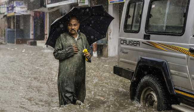
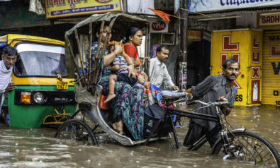
India is aiming to prevent future catastrophes, such as the recent flashfloods.
A spell of torrential rainfall during June, 15-17, 2013, over Uttarakhand, India, caused devastating floods and landslides in the country's worst natural disaster since the 2004 Tsunami. According to figures released by the Uttarakhand State government, more than 5,000 people were presumed dead. Destruction of bridges and roads trapped more than 100,000 pilgrims and tourists in the valley. The largest impact was at the temple town of Kedarnath, which saw the height of the annual pilgrimage season.
During the prolonged rain spell, more than 20 inches of rainfall was recorded in the region. This was caused by an interaction between the early monsoon flow and a mid-latitude weather system. Prevailing atmospheric circulation over northwest India was conducive to the transportation of huge amounts of moisture from the Arabian Sea to the region. The mid-latitude weather system provided an adequate dynamical mechanism for intense precipitation. Adequate forecast for heavy to very heavy rainfall over this region was issued by the Earth System Science Organization — India Meteorological Department (ESSO — IMD), the national weather agency in India.
Snow, Ice and Rain
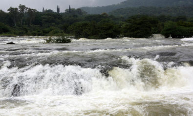
The Kedarnath Dham (a Hindu pilgrimage site) is located on the banks of the Mandakini River, which originates from the Chaurabari glacier. It is situated between two channels that run from two snouts of the glacier, separated by a thick pile of moraines. During the last glacial maxima (a period in the Earth's climate history when ice sheets were at their maximum extension), this region was under glacial ice. Thus, the Chaurabari glacier was formed only during the peak of the last glacial period. The Himalayas, being the youngest mountain ranges in the world, are also among the most unstable, rendering the glacial region vulnerable to the slightest of weather extremities.
The heavy to very heavy early rains (five to nine inches) in the Kedarnath region, starting from June 14, lasted four days. During June, the glacier upstream of Kedarnath was covered by thick snow. Heavy snowfall in the glacial region was reported just before June 14. The rain falling on snow and ice resulted in fast melting of the glacier.
It has been shown that water flow can increase up to four times due to melting of snow and ice, exacerbated by rain. This clarifies the large stream run-off in the Madakini River, but does not explain peak discharge for short duration on the morning of June 17. The possible explanation, according to the Indian Space Research Organization (ISRO), is based upon remote sensing satellite (Resourcesat and Cartosat) images before and after the event. Water and debris breached the boundaries of the Chaubari Lake (also Charbari Lake), and thus further increased the river flow and entered the town. In the process, the river also changed its course. The heavy rainfall, melting snow, and the breaching of a lake resulted in a flow with large amounts of debris which devastated the entire valley. The heavy rainfall in the entire catchment further increased the magnitude of floods downstream.
Global Warming?
Can this extreme rainfall in Uttarakhand be attributed to global warming?
It is not possible to link any individual weather or climatic event to global warming. However, in the recent past, such occurrences have happened very frequently over South Asia. The 2010 Pakistan floods and the 2005 Mumbai deluge are two cases in point.
Studies show that there has been a 50 percent increase in extreme rainfall over the past 50 years in India. This suggests a substantial increase in flood-related hazards in the rain-affected regions.
The global climate is getting warmer, as is evident from increasing surface-air temperatures, widespread melting of sea ice and snow, and the rise in the world's sea-level. Climate model projections suggest that as the Earth warms, precipitation is likely to fall over shorter intervals of time, thereby increasing the frequency of very heavy and extreme precipitation events.
There is evidence that anthropogenic influences, including increasing atmospheric greenhouse gas concentrations, have changed these extremes. The increase in heavy rainfall events may enhance river discharge and the likelihood of floods in a number of major river basins.
Since global warming is likely to increase the frequency of extreme rainfall events, it is essential for us to develop suitable technology and methodology to tackle such events in the future.
The scale of extreme weather events like intense precipitation is unknown. Therefore, predicting such events is difficult as chances of detecting a low-scale incident, however climatically unusual, are low. As a result, such events cannot be predicted with great precision well in advance.
Accurate forecasts are often hampered by inadequate observations and limited understanding of the physical processes involved. It is through state-of-the-art weather prediction models, that general areas where the important weather systems are likely to form can be predicted in advance. However, predicting the location, timing, and severity depends upon continual monitoring, using dense observations and high-resolution regional weather prediction models with suitable data assimilation. Such technologies and techniques do not exist in Uttarakhand at present.
Developing Early-Warning Systems
Many weather incidents like the Uttarakhand rainfall may be characterized as “low probability” but “high risk.” The warning products based on deterministic values provide users with the best estimate of what will happen. However, for optimal decision-making, one needs to consider the range of likely outcomes using probabilistic forecasts. Prediction of extreme weather events needs to be a multi-tiered process — first an advisory based on ensemble probabilistic forecast, followed by a watch, and then an outlook — that reflects growing uncertainty as forecast lead-time increases.
The forecast dissemination system needs to be automated to generate instant alert and warning messages and tailor the forecast products. Advances in digital technology will soon help the implementation of this type of efficient and automated forecast dissemination strategy in India. Regarding the context of a changing climate, forecasts and warnings of extreme weather that can be disseminated rapidly and efficiently become extremely critical.
ESSO, a community of scientists constituted by the Indian government, in collaboration with the Ministry of Earth Sciences (MoES), has planned to augment observational and modeling capabilities to meet this important requirement. At present, a multi-tiered process of forecast is in existence only for the prediction of tropical cyclones in India.
ESSO-MoES has planned to introduce such a multi-tiered process in case of extreme events like intense precipitation and severe heat waves. Under the Himalayan Meteorology Program — launched by the government for developing capabilities for providing special forecasts — it has been planned that the observing system by deploying Doppler Weather Radars (DWR), rain radars, automatic weather stations and rain gauges, and upper air observations shall be improved and modernized. The assimilation of DWR data in meso-scale models will facilitate now-casting (anticipating an event only few hours in advance).
The initiative will lead to improved understanding of weather and climate processes in general, and high impact weather events particularly, in the Himalayan terrain. This will pave way for developing early warning systems for extreme weather events.
The views expressed in this article are the author's own and do not necessarily reflect Fair Observer’s editorial policy.
Image: Copyright © Shutterstock. All Rights Reserved
Support Fair Observer
We rely on your support for our independence, diversity and quality.
For more than 10 years, Fair Observer has been free, fair and independent. No billionaire owns us, no advertisers control us. We are a reader-supported nonprofit. Unlike many other publications, we keep our content free for readers regardless of where they live or whether they can afford to pay. We have no paywalls and no ads.
In the post-truth era of fake news, echo chambers and filter bubbles, we publish a plurality of perspectives from around the world. Anyone can publish with us, but everyone goes through a rigorous editorial process. So, you get fact-checked, well-reasoned content instead of noise.
We publish 3,000+ voices from 90+ countries. We also conduct education and training programs
on subjects ranging from digital media and journalism to writing and critical thinking. This
doesn’t come cheap. Servers, editors, trainers and web developers cost
money.
Please consider supporting us on a regular basis as a recurring donor or a
sustaining member.
Will you support FO’s journalism?
We rely on your support for our independence, diversity and quality.


Comment