
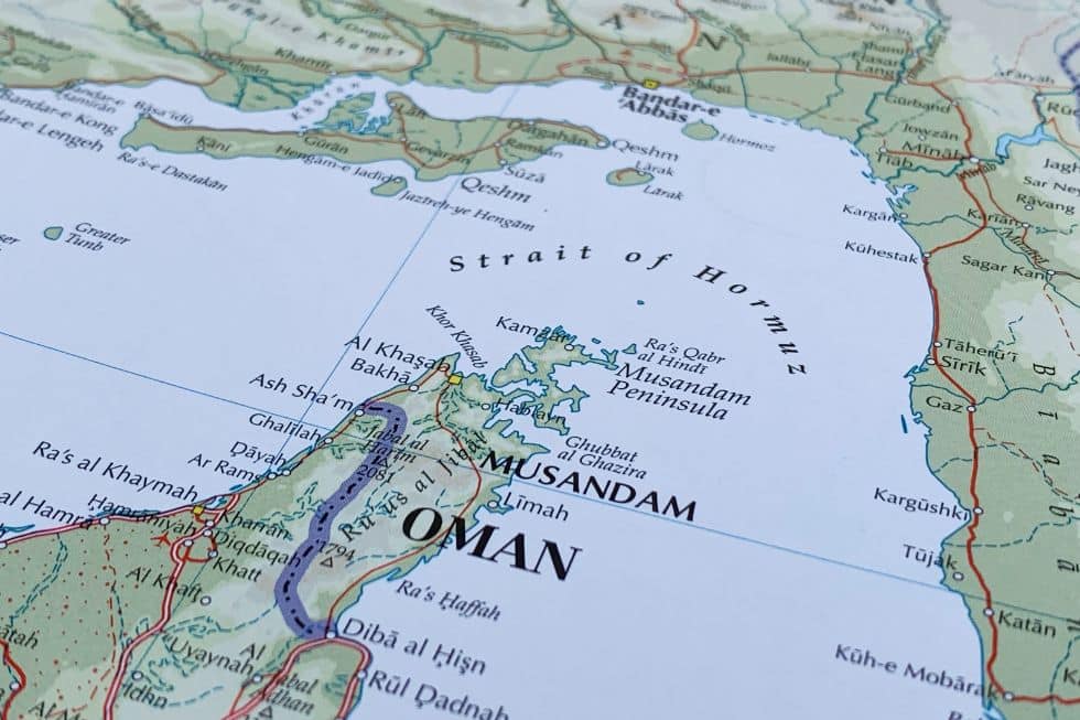
Current events in the Strait of Hormuz have highlighted the huge importance of maritime routes. These are shaped by compulsory points of naval passage, located in strategic locations that act as chokepoints. They represent the compulsory crossing of waterways between oceans, between oceans and seas, and between seas.
Their significance is linked to that of maritime transport itself, which represents the fundamental bloodstream of global trade. This transport carries 80% of the world’s trade by volume, carrying vital crude oil and other raw materials, semi-processed goods or finished products. As such, it plays a fundamental role within international supply chains.
Different kinds of maritime routes
Maritime routes can be man-made or natural. Among the first group are the Panama and the Suez canals. Within the second, among others, are the Hormuz, Malacca or Gibraltar straits. In both cases, they represent funnels of high strategic significance. Some more than others, of course. Indeed, according to their strategic importance, they can be divided into primary and secondary chokepoints. The former refers to connectors that, if disrupted, could seriously impair global trade. The latter, on the contrary, represent support maritime passages that entail significant detours in the event of disruption. The best example of a primary chokepoint is the Strait of Hormuz, while the Strait of Taiwan, the Sunda Strait (between the islands of Java and Sumatra) or the Dover Strait are examples of secondary ones.
The top four
The top four maritime routes (or chokepoints) are the Strait of Hormuz, the Strait of Malacca, the Suez Canal and the Panama Canal. The first of them represents the compulsory crossing pathway between the Persian Gulf and the Indian Ocean. Beyond being a very important merchandise transit route, representing 11% of the global seaborne trade, it is one of the world’s two main energy chokepoints. It is indeed the inescapable transit route for 20 to 21 million barrels of oil per day, representing 20% of global oil consumption and 25% to 30% of global seaborne oil trade. At the same time, it is the passage route for 20% of the global liquified natural gas (LNG) trade. Some of the world’s largest hydrocarbons exporters — Saudi Arabia, Iran, Iraq, Kuwait, Qatar and the United Arab Emirates (UAE) — rely on this route, as do the largest Asian consumers: China, India, Japan and South Korea.
The Strait of Malacca connects the Indian Ocean to the South China Sea (in the Pacific Ocean). It is the route through which 30% of global trade and 23.7 million barrels of oil pass daily. This includes two-thirds of China’s trade volume and around 80% of its energy imports. It is located between the island of Sumatra (Indonesia) and the Malay Peninsula (Malaysia and Singapore). Around 29% of the global seaborne oil trade passes through the Strait of Malacca. In fact, to reduce its critical reliance on the Strait of Malacca, China has developed a major energy corridor through Myanmar. A corridor consisting of two parallel pipelines transporting crude oil and natural gas from the Indian Ocean coast of Myanmar to Southwestern China.
The Suez Canal, on its part, connects the Mediterranean Sea with the Red Sea, which leads to the Indian Ocean. Between 12% and 15% of worldwide trade and about 30% of global container traffic transits this route. Roughly 9% of the global seaborne oil flows (about 9.2 million oil barrels a day) and 8% of liquified natural gas (LNG) volumes use this route.
The Panama Canal connects the Pacific and the Atlantic oceans. About 5% of global marine trade passes through it. Meanwhile, 2.3 million barrels of oil per day pass through this waterway. However, while the Suez Canal allowed for the transit of supertankers of up to 200 thousand tons, the Panama Canal was limited to 65 thousand tons and to a configuration adapted to its particular standards. The so-called Panamax standards. Since 2014, as a result of the expansion of the canal, the New-Panamax standard has applied, substantially increasing both capacity and tonnage — now reaching 120,000 tons.
Other maritime routes
In addition to the aforementioned big four maritime routes, the Cape of Good Hope and the Strait of Magellan must also be mentioned. While the former connects the Atlantic and the Indian oceans at the South of the African continent, the latter links the Pacific and the Atlantic oceans through the Southern seas of South America. The Cape of Good Hope has much greater strategic significance, not only because the economic emergence of China and the Indo-Pacific sphere has enhanced its relevance, but also because the Strait of Magellan has lost much of its significance in the last few decades. This was a result of the 1980s transcontinental intermodal freight system, which allowed for the massive transport of containers between the US’s East and West coasts.
However, the Strait of Magellan could have better days ahead if climate change keeps affecting the Panama Canal. Indeed, lack of water has hampered canal operations in recent years. In 2023, the El Niño climate phenomenon, which impacted rainfall, caused water levels to plunge in the lakes that feed the canal, leading to a forced reduction in vessel crossings.
Of much relevance, as well, are the Strait of Gibraltar, the Turkish straits (Bosphorus and Dardanelles) and the Danish straits (Kattegat and Skagerrak). They respectively connect the Atlantic Ocean and the Mediterranean Sea, the Mediterranean Sea and the Black Sea (through the Sea of Marmara), and the Baltic Sea with the North Sea.
As a result of global warming, two additional major maritime routes are opening in the Arctic — the North-East route (bordering Canada) and the North-West route (bordering Russia). While they are considered interior waters by both Canada and Russia, the US asserts that they are international straits conferring open transit rights. The US, indeed, rejects both countries’ claims as illegitimate. The geopolitical and economic significance of the Arctic routes may be enormous, as they could represent new active passages between the Atlantic and the Pacific oceans. This would diminish the geostrategic importance of the Strait of Malacca and, as a consequence, that of Singapore as a maritime hub.
Highly sensitive geopolitical spots
Needless to say, in addition to their economic relevance, or precisely because of it, maritime routes are highly sensitive geopolitical spots. The Suez Canal has a longstanding history in this regard. In 1956, after Egypt’s President Gamal Abdel Nasser nationalized the canal, an invasion by Britain, France and Israel took place. For several months, the canal remained closed, significantly disrupting global shipping and trade. Ten years later, in 1967, the Suez Canal was again closed, as it became the frontline between the combatant forces of Israel and Egypt, during the Six-Day War. Following the conflict, this waterway remained shut for eight years, adding around 8,000 to 10,000 kilometers to trade shipping routes that depended on the canal.
At the opposite end of the waterway that connects with the Suez Canal — in the Southern tip of the Red Sea that joins the Indian Ocean — there have also been recent problems. In the Bab el-Mandeb Strait and the Gulf of Aden, the Iranian-backed Houthis of Yemen have been attacking commercial shipping since the end of 2023. This is in retaliation for Israel’s war in Gaza.
Although the Strait of Malacca is not a contentious international spot, its adjacent South China Sea remains one of the world’s most disputed maritime areas. Stepping over the claims of several South East Asian countries, as well as over the normative of the UN Convention on the Law of the Sea and the jurisprudence of the International Court of Justice, China asserts its rights over 90% of the South China Sea.
Moreover, in 2010, Chinese Foreign Minister Yang Jiechi declared that the sea represented a “core national interest” for his country, while telling his Southeast Asian counterparts at an Association of Southeast Asian Nations (ASEAN) meeting that “China is a big country and other countries are small countries, and that’s just a fact.” Additionally, in order to assert control over this waterway, China has built and militarized to the teeth 27 artificial islands within it.
China’s claims are not only rejected by its South China Sea neighbors but also by the US and a significant part of the international community. The US and many Western nations assert a right of free passage through this sea, challenging China’s claim by periodically sailing its warships through it. Although 80% of China’s crude oil imports and the bulk of its exports sail through this waterway, the same happens to Japan, South Korea and Taiwan. Moreover, it is a vital trade route for the 620 million people who inhabit Southeast Asian countries. A trade of more than $5.3 trillion takes place annually in those waters, representing more than one-third of the world’s maritime traffic.
The Panama Canal has also become a sensitive geopolitical spot in recent times. By asserting American rights under the Monroe Doctrine, US President Donald Trump has threatened to take it, while forcing Chinese interests out of the canal. Indeed, Hong Kong’s company CK Hutchinson, which controlled two ports within it, was ousted as a result of Washington’s pressure and forced to sell such assets to the American BlackRock group. However, the Sword of Damocles represented by Trump’s threat of taking possession of the Panama Canal has not disappeared.
Geopolitical significance of the Strait of Hormuz
The previous geopolitical issues provide the background for the current state of belligerence in the Strait of Hormuz. America’s bombardment of Iran, being the result of a war of choice, led to what should have been anticipated — Tehran’s blockade of the strait. This has led to an increase in oil prices that, amid fluctuations, have reached up to 40% above pre-crisis levels, while halting about 20% of global oil and liquified natural gas flows. This makes the current crisis even worse than the two oil shocks of the 1970s put together.
This situation had its antecedent in the so-called Tanker War of 1984–1988, a critical phase of the Iran-Iraq War, during which both sides targeted oil shipping in the Persian Gulf. As a result of Iraq’s attacks on Iranian oil exports, Iran retaliated by targeting not only Iraqi shipping but also neutral vessels. Over 400 oil tankers and commercial ships were struck during that period, making the targeting of civil shipping a tool of war. More recently, as mentioned before, the Houthis carried out attacks on commercial shipping in the Red Sea, in retaliation for events in Gaza.
Both cases show a worrisome pattern of maritime insecurity. Within it, state and nonstate actors exploit maritime chokepoints to exert pressure on global energy flows as an instrument of war. Maritime routes represent the ideal setting for asymmetric warfare, as they allow for weaker actors to exploit geography, cheaper technology and economic vulnerability to inflict maximum damage. Whereas in sea or on land, narrow paths have always been the perfect spot for the few to successfully confront the many. A good historical example in this regard dates back to 480 BC, when King Leonidas’s 300 Spartan hoplites stopped for several days hundreds of thousands of Persian invaders, at the Pass of Thermopylae.
Current events in the Strait of Hormuz have become a perfect example of both the paramount importance and the extreme vulnerability of maritime routes. Especially so when there are no alternative routes involved, as in this case. Contrary to the closure of the Suez Canal in the 1960s and 1970s, which had an optional, although much longer shipping route around the Southern tip of Africa, the Strait of Hormuz presents no alternative. There is no other waterway, indeed, to go in or out of the Persian Gulf.
[Kaitlyn Diana edited this piece.]
The views expressed in this article are the author’s own and do not necessarily reflect Fair Observer’s editorial policy.
Guarding the Gates of the Global Fortress: Great Power Rivalry at Global Strategic Chokepoints
Contemporary great power competition is shifting toward strategic “gateways” of the international system — regions where geopolitical influence, economic infrastructure...
The Middle East War Could Finally Push Indonesia Toward Renewable Energy
The conflict between the US, Israel and Iran is disrupting global oil markets, driving prices higher and threatening Indonesia’s energy...
FO Exclusive: A New Iran–US Conflict Looms Large
In this section of the February 2026 episode of FO Exclusive, Atul Singh and Glenn Carle examine the rising risk...

Support Fair Observer
We rely on your support for our independence, diversity and quality.
For more than 10 years, Fair Observer has been free, fair and independent. No billionaire owns us, no advertisers control us. We are a reader-supported nonprofit. Unlike many other publications, we keep our content free for readers regardless of where they live or whether they can afford to pay. We have no paywalls and no ads.
In the post-truth era of fake news, echo chambers and filter bubbles, we publish a plurality of perspectives from around the world. Anyone can publish with us, but everyone goes through a rigorous editorial process. So, you get fact-checked, well-reasoned content instead of noise.
We publish 3,000+ voices from 90+ countries. We also conduct education and training programs
on subjects ranging from digital media and journalism to writing and critical thinking. This
doesn’t come cheap. Servers, editors, trainers and web developers cost
money.
Please consider supporting us on a regular basis as a recurring donor or a
sustaining member.
Will you support FO’s journalism?
We rely on your support for our independence, diversity and quality.

Comment