


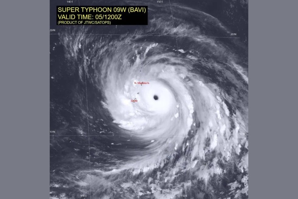



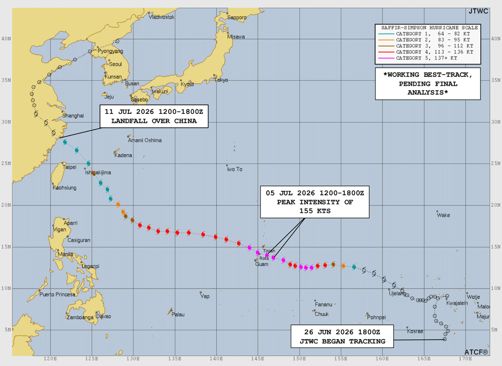
Between June 25 and July 14, 2026, what seemed to be a simple tropical depression in western North Pacific, developed into a super typhoon. Typhoon Bavi, also called Inday in the Philippines, was the second super typhoon of the 2026 Pacific typhoon season. Over just a couple of weeks, the storm swept through Guam, the Northern Mariana Islands and near Taiwan before making its final landfall in eastern China, triggering heavy rains and landslides that ultimately killed dozens of people and left dozens more missing across the Philippines.
I had the chance to discuss it with Brian Howell, a civilian Typhoon Duty Officer with the 1st Weather Group, US Air Force, serving at the Joint Typhoon Warning Center (JTWC) — a joint United States Navy and Air Force command based in Pearl Harbor, Hawaii. JTWC is responsible for issuing tropical cyclone (TC) warnings across the Pacific and Indian Oceans on behalf of the US Department of Defense, covering roughly 85% to 89% of the world’s tropical cyclone activity. Civilian agencies and forecasters throughout the region rely on its forecasts.
Below is the written interview. My questions are bolded.
The interview
Bavi went from a tropical depression to a Category 5 super typhoon (JTWC’s highest tier, for sustained winds above 150 mph) in a very short window near the Marianas, and its intensity kept swinging up and down after that as it approached China. What conditions let a storm intensify that fast, and was there anything about Bavi’s environment that made it happen so quickly?
Brian Howell: A tropical cyclone requires three main ingredients to rapidly intensify: a deep-layer of warm ocean waters, a strong outflow mechanism in the upper atmosphere that evacuates mass from the column and favorable (low) vertical wind shear conditions. [Author’s note: Wind shear refers to a difference in wind speed or direction at different altitudes, which can tear a storm apart if too strong.]
In the case of Bavi, all three parameters were in a near-optimum state. The ocean waters were anomalously warm east of Guam due to the strong El Niño, which provided a robust source of energy for the storm.
In the upper atmosphere, the wind shear was very low and there was strong divergent flow over the top of the circulation which supported dramatic and rapid bursts of deep convection to form an eye and continue to deepen the system.
You mentioned the anomalously warm waters east of Guam tied to the strong El Niño. [El Niño is a recurring warming pattern in the central and eastern Pacific that influences global weather, including tropical cyclone activity.] Beyond this specific event, do you see storms like Bavi becoming more frequent as part of a broader pattern? I know this might be more a climate-science question than an operational forecasting one, but what are your thoughts?
Howell: As you mention, this is more of an issue about long-term climatological trends vice an operational one. While we have seen a subtle signal indicating an increase in the number of strong tropical cyclones over the past few years, we aren’t sure if this is a true signal in the climatology of TC activity, or an artifact of improved detection technology and analysis techniques.
Bavi went through three separate eyewall replacement cycles over its lifetime: each time weakening and then reintensifying before wind shear and the third cycle finally broke it down for good on its way toward China. Can you explain what’s physically happening inside the storm during one of these cycles? [Eyewall replacement cycle is a process where an outer ring of thunderstorms gradually replaces a storm’s original eye, temporarily weakening then restrengthening it.]
Howell: Eyewall replacement cycles (ERC’s) frequently occur in intense tropical cyclones, particularly those reaching 100 kts [185 km/h, or 115 mph] or higher peak winds. However, the timing, duration and outcome of ERCs are extremely difficult to predict.
For example, an ERC event may take anywhere from hours to days, and the cycle may fail to complete, or it may complete and immediately initiate a new cycle. During an ERC, an outer ring of convection first forms at the fringes of the circulation, usually about two to three times the size of the inner eyewall.
Once this outer ring forms, it begins to choke off the inflow of air to the inner eyewall, depriving it of the fuel to maintain itself. Cut off from its energy source, the inner eyewall shrinks in size and eventually collapses, replaced by the new, larger eyewall.
When the inner eyewall erodes, the cyclone weakens as the central pressure adjusts to the new, larger eyewall. Once the outer eyewall begins to contract, the system will usually reintensify.
The storm was unusually large, with gale-force winds extending from Taiwan through the Ryukyus even before landfall. Does a storm’s physical size scale with its intensity, or are those two fairly independent properties?
Howell: We like to say size doesn’t matter when talking about tropical cyclones. One can have very large storms which are very strong or relatively weak, and the opposite is also true. The two properties are independent of one another.
Rapid intensification is more common in smaller systems, since there is less mass that needs to rotate, and it can respond quickly to a deepening eye. Whereas larger systems tend to weaken more slowly, as they have more momentum to dissipate.
How far out was JTWC forecasting Bavi’s eventual landfall in China, and how much did that track prediction shift over time? What makes a storm’s future path more or less predictable, and where does most of the remaining uncertainty come from at that stage?
Howell: We first predicted landfall in China on July 6, when the system was located northwest of Guam, roughly five days out from landfall. JTWC produces forecasts that extend out to 120 hours (five days) from the initial time of the forecast.
We take great pride in the accuracy of our forecasts. In this case, for the five-day period leading up to landfall, our forecasts deviated from the system’s actual track by no more than 75 nautical miles at most.
These are historically low forecast errors, and dramatically better than the typical average error ten to 20 years ago. Areas of high pressure, or anticyclones, steer tropical cyclones. [Anticyclones are areas of high atmospheric pressure that push and guide a storm’s path, similar to how a current steers a boat.]
Changes in the strength orientation of these anticyclones drives the predictability of the forecast over time. Track forecast uncertainty is highest when steering flow is weak, or when there are competing steering mechanisms, leading to a larger spread of potential outcomes that we must consider.
Did JTWC coordinate directly with Chinese meteorological services as Bavi approached landfall, or do you operate independently while the China Meteorological Administration (CMA) issues its own warnings?
Howell: We did not coordinate with the CMA as Bavi approached landfall. As a matter of routine, JTWC does not coordinate our forecasts with any other forecast agency, and we all generate our own, independent forecasts.
After reaching its Category 5 peak between July 5 and 6, Bavi weakened rapidly on approach to China. What intensity was it at when it actually made landfall near Yuhuan on July 11? What cuts off a storm’s energy supply once it moves over land?
Howell: We estimated the intensity to be 80 kts [148 km/h, or 92 mph] when the storm made landfall in eastern China. Heat fluxes from the ocean provide the energy source for tropical cyclones. Moving over land removes this energy source.
Combined with the frictional effects of terrain that tear apart the low-level vortex structure, tropical cyclones normally rapidly weaken and dissipate over land.
You watched this storm from formation near Kwajalein on June 25 through dissipation in mid-July. As a forecaster, what’s the moment in a storm’s life cycle where you’re most uncertain, and how does JTWC handle communicating that uncertainty to the public and to decision-makers?
Howell: The most uncertain time in a typical TC’s lifetime is during the formation phase, when the structure is weakest and most ill-defined. One of the most important functions the forecasters perform is generating something called the “TC Vitals,” which is basically where we analyze all available data to generate a set of parameters which we insert into the forecast models to describe the TC’s current position, intensity and structure.
During the early part of the storm’s lifecycle when the cloud patterns are disorganized, the center of the system is challenging to locate and analyze. This is particularly true if there is limited data available to diagnose what is taking place below the clouds in traditional visible or infrared satellite imagery.
If we don’t have high confidence in where the system is located, how strong it is or what the structure looks like, then those uncertainties carry forward into the model output, generating uncertainty in the entire forecast.
We communicate these uncertainties via our Prognostic Reasoning messages, which we produce as part of our warning suite for every TC forecast. In these messages, we discuss confidence in the initial position, intensity and structure, and do the same for the forecast points.
A nearly unfathomable natural wonder
It is one thing to read that a storm reached winds of 285 km/h, and quite another to try to actually picture what that means: a mass of air and water, larger than entire countries, spinning with a force that can tear apart buildings and reshape coastlines, born from nothing more than warm ocean water and a favorable arrangement of the atmosphere above it. It’s so far removed from things we see every day that it’s difficult to visualize.
This is part of why I wanted to build something interactive for this piece, rather than simply describing Bavi’s path in words. A typhoon in the western North Pacific can feel very far away, an abstraction made of acronyms. But watching its intensity rise and fall, hour by hour, across its own timeline — tracing its evolution as Howell described, watching the storm climb to Category 5 and fall back more than once before its final landfall — is a small way of bringing that distance closer, of letting readers hold the storm’s life cycle in their own hands.
And I find something quite moving in how much of what drives a storm like Bavi traces back to physics most of us encountered in a classroom long before we ever thought about typhoons. Looking at the plots, I’m tempted to reach for Bernoulli’s principle here. That same idea explains how an airplane wing generates lift: Where air moves faster, pressure drops. A typhoon’s eye, with its howling winds circling a low-pressure core, is a large-scale echo of that same intuition, even if the full picture — a vortex held in balance between pressure, rotation and the Earth’s own spin — is more intricate than any single equation from a physics textbook. Still, it serves as a reminder that the same basic rules governing the world around us, at every scale, connect basic physics to a super typhoon crossing the ocean.
[Lee Thompson-Kolar edited this piece.]
The views expressed in this article are the author’s own and do not necessarily reflect Fair Observer’s editorial policy.
The Leadership Team from Hell on a Hell of a Planet
With an El Niño event forecasted to trigger extreme weather this summer, the world needs a strong governmental response. US...

Eleven Storms, One Season: Vietnam on the Frontlines of Climate Change
Typhoons keep battering Vietnam, testing both resilience and regional cooperation. As seas warm and storms intensify, the country’s struggle reveals...
When COVID-19 and Hurricanes Collide
It is critical that migrant workers have access to economic opportunities to be able to help their communities recover from...

Support Fair Observer
We rely on your support for our independence, diversity and quality.
For more than 10 years, Fair Observer has been free, fair and independent. No billionaire owns us, no advertisers control us. We are a reader-supported nonprofit. Unlike many other publications, we keep our content free for readers regardless of where they live or whether they can afford to pay. We have no paywalls and no ads.
In the post-truth era of fake news, echo chambers and filter bubbles, we publish a plurality of perspectives from around the world. Anyone can publish with us, but everyone goes through a rigorous editorial process. So, you get fact-checked, well-reasoned content instead of noise.
We publish 3,000+ voices from 90+ countries. We also conduct education and training programs
on subjects ranging from digital media and journalism to writing and critical thinking. This
doesn’t come cheap. Servers, editors, trainers and web developers cost
money.
Please consider supporting us on a regular basis as a recurring donor or a
sustaining member.
Will you support FO’s journalism?
We rely on your support for our independence, diversity and quality.





Comment